FROM GARFIELD COUNTY EMERGENCY MANAGEMENT-SATURDAY JULY 15, 2017
WARM AND HUMID are the words for today. Storm chances are still in the air around the area so keep this in mind. Speaking of storms, yesterday I saw a few posts that were INTERESTING in the Carrier area. I had a few calls concerning dust devils up there and then I see a few pics from folks that appear to look like land spouts. Those are not common in our area but I HAVE A REQUEST.
During storm development, crazy things can happen. Instead of just posting those pics on Facebook or whatever, I would really like you all to send those to me too. I prefer those be sent through the DAMAGE REPORT portion of our GARFIELD COUNTY EM APP. Since we are the WARNING AGENCY for the county, this would help us in making those decisions. RADAR doesn’t see what’s happening from the cloud base to the ground. NO RADAR DOES, contrary to what some TV folks tell you. YOU DO. This is why I am asking that you all help me out along this line. When you take a picture, take it from the ground up and take another from the cloud base to the ground as best you can. This helps us determine whether it is surface based by wind or possibly cloud based. It could have been a small tornado WHERE CIRCULATION wasn’t strong enough to be seen on radar. THIS DOES HAPPEN. If you don’t have our app, download it or just email the pics to mike@gcem.org
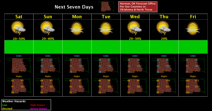
Here is your forecast from the NWS/NORMAN;
Saturday-20 percent chance of showers and thunderstorms. Partly sunny, with a high near 94. Heat index values as high as 100. East wind around 8 mph.
Saturday Night-30 percent chance of showers and thunderstorms, mainly before 1am. Mostly cloudy, with a low around 74. East wind 6 to 8 mph.
HAVE A SUPER DAY!!
MIKE