FROM GARFIELD COUNTY EMERGENCY MANAGEMENT-SATURDAY JUNE 17, 2017
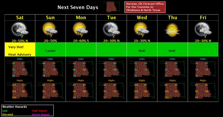
THE NWS HAS ISSUED AN “EXCESSIVE HEAT WARNING” IN EFFECT FROM 11 AM THIS MORNING UNTIL 9 PM CDT THIS EVENING. HIGH TEMPS 100-106 ARE FORECAST HERE ALONG WITH HIGH HUMIDITY WILL PUT THE HEAT INDEX FROM 106 TO 112 DEGREES.BE EXTREMELY CAREFUL WHILE OUTDOORS TODAY.
A cold front will move through the area later this evening. It may bring showers and thunderstorms with it. If so, strong winds, hail, and heavy rainfall are the main threats. One good thing about the front—cooler temps for Sunday- low in mid 80’s.
Here is your forecast from the NWS/NORMAN:
Saturday-Sunny and hot. High near 103. Heat index values as high as 110. South winds 5 to 10 mph.
Saturday Night-50 percent chance of showers and thunderstorms. Low around 69. South win 10 to 20 mph becoming north northeast after midnight. Winds could gust as high as 25 mph. New rainfall amounts between a tenth and quarter of an inch, except higher amounts possible in thunderstorms.
DOWNLOAD OUR “GARFIELD COUNTY EM” APP!!
HAVE A SUPER DAY AND STAY SAFE!!
MIKE