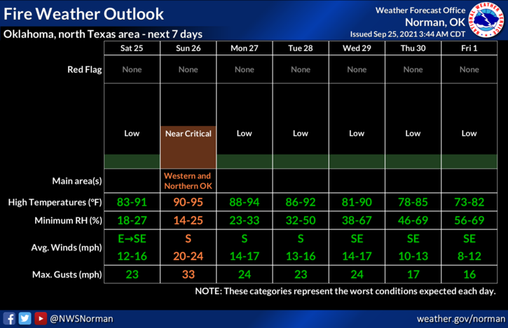
0410L-SATURDAY OUTLOOK FROM GARFIELD COUNTY EMERGENCY MANAGEMENT-9/25/21
1- Low dewpoint temps along with low humidity but today with lighter winds won’t help the FIRE DANGER but it will mitigate the spread if fires occur. Fire does create its own weather but with lighter winds we can generally get the better of it sooner than later. Just be careful utilizing anything related to fire. Any controlled burning today we ask that you plow a fire break around the area that you will burn and please stay out there just in case. SUNDAY will be a dangerous day for fire weather so we’ll ask in advance for NO CONTROLLED BURNING. Thanks.
2- Weather-wise, temps in the 80s along with light winds will give us a fairly mild day. A cold front did push through late last night bringing us mostly a wind shift. Temps will be a slight bit cooler but not really noticeable from yesterday. Just get outside and enjoy it.
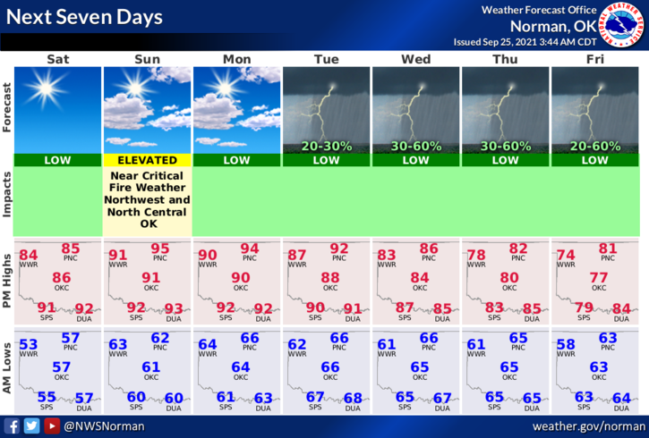
3- Next week, there are some rain chances but if rain does occur, based on guidance right now, Wednesday looks to be the better of all of them right now. Probabilities are fairly low so we’ll see what verifies and what doesn’t. Here is your forecast from the NWS/NORMAN;
Today-Sunny. Highs in the upper 80s. East winds 10 to 15 mph.
Tonight-Clear. Lows in the upper 50s. Southeast winds around 10 mph.
STAY SAFE!
MIKE