0330L-SUNDAY OUTLOOK FROM GARFIELD COUNTY EMERGENCY MANAGEMENT-10/24/21
1- Another front will be affecting the area today. Timing for the front through our area is roughly 1100-1400L. It could vary depending on speed. A few storms overnight didn’t produce a lot of rainfall but we’ll take whatever we can get. We aren’t expecting any more rainfall here with this front but severe weather is expected later today in eastern Oklahoma, Northern Arkansas, and southern Missouri. If traveling that way, use extreme caution.
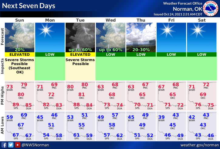
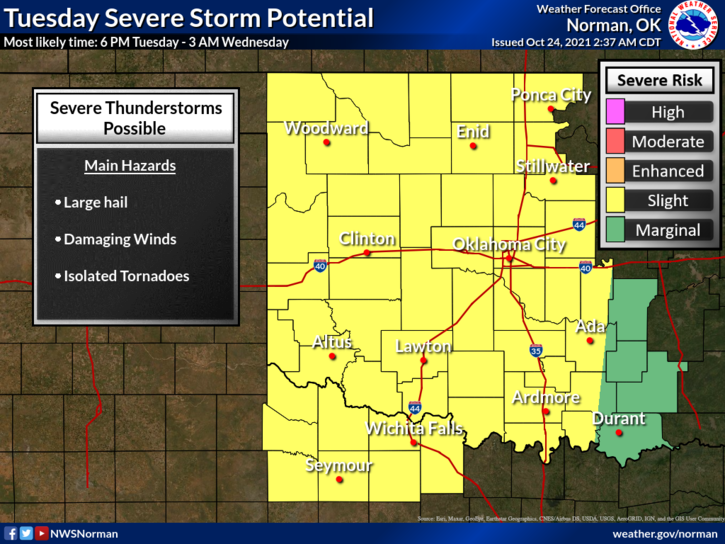
2-For us, we’ll have a chance for severe weather Tuesday as another stronger front pushes in bringing temps down possibly into the 60s for highs and the 40s for lows. We’ll see what happens. For now, enjoy the day!! Here is your forecast from the NWS/NORMAN;
Today-Partly cloudy. Highs around 80. Southwest winds around 20 mph with gusts to around 40 mph shifting to the northwest 10 to 20 mph in the afternoon.
Tonight-Clear. Much cooler. Lows in the mid-40s. Northwest winds around 10 mph shifting to the northeast after midnight.
COMMENT: Many folks have complained about the LOCAL WEATHER feature on our GARFIELD COUNTY EM app. I have it linked to the NWS in Norman because I wasn’t really happy with the new product my app folks were going to use. THAT SAID, all information you could possibly want, forecasts, discussions, radar, satellite, etc are all on the NWS SITE. I do not plan on changing this. TAKE THE TIME to navigate around the NWS site and become familiar with it. I feel over time, you will begin to realize that it actually is better than what we had before.
More on this later. HAVE A GOOD DAY!
MIKE