0420L-THURSDAY OUTLOOK AND INFO FROM ENID/GARFIELD COUNTY EMERGENCY MANAGEMENT-1/17/19
1) The fog and mist should clear out gradually this morning bringing us partly cloudy conditions this afternoon.
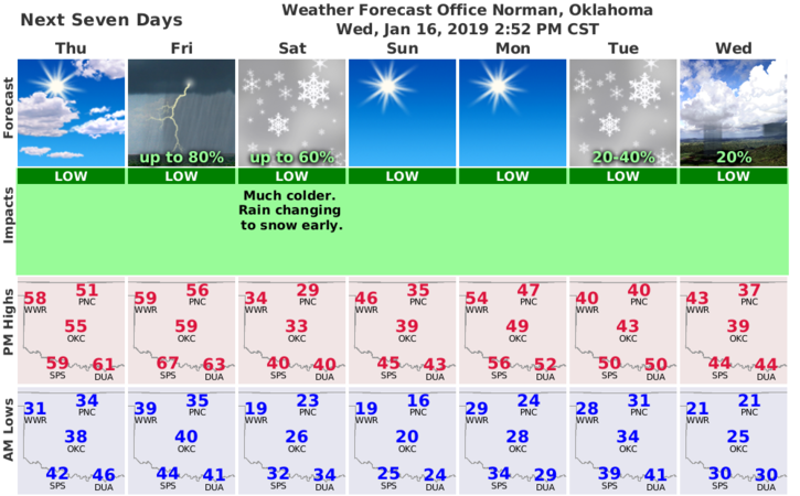
2) The storm system everyone is either excited or depressed over is coming ashore so we’ll see how it actually develops. Guidance seems to see it more progressive than before meaning that even with colder air coming in, the system will move quickly and our snow chances actually lessen some. That window is late Saturday evening possibly through Saturday morning. If we see snow, maybe an inch or so is my guess.
3) KEEP THIS IN MIND!! There are uncertainties involved here as this system reaches shore as speed, moisture return, storm track, frontal timing, depth of moist and dry layer aloft, and several other factors I can’t pronounce will affect what happens. NOTHING IS SET IN STONE YET.
4) My biggest worry will be how cold we actually get and the wind chill. These are our biggest issues as I see it. We may even see a thunderstorm on Friday before the main system gets here per the SPC. We’ll see what happens.
5) Here is your forecast from the NWS/NORMAN;
Thursday- Cloudy through mid-morning then gradual clearing with a high near 53. Northwest winds 5 to 10 mph becoming south in the afternoon.
Thursday Night- Mostly clear with a low around 38. Light southeast winds becoming south southeast 5 to 10 mph in the evening.
HAVE A SUPER DAY!!
MIKE