0345L-FRIDAY OUTLOOK FROM GARFIELD COUNTY EMERGENCY MANAGEMENT-1/18/19
We have added ROAD CONDITIONS FOR ALL STATES AROUND Oklahoma and OG&E System Watch to the front page of our www.gcem.org website. Also, get our GARFIELD COUNTY EM app. You’re not prepared without it.
1) WIND ADVISORY IN EFFECT FROM 9PM TONIGHT UNTIL 8 AM SATURDAY MORNING. NORTH WINDS 25-35 MPH GUSTING TO 50 MPH ARE POSSIBLE.
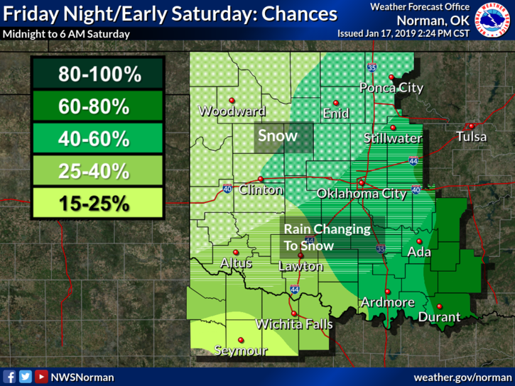
2) A COLD FRONT will push through the area this afternoon bringing much colder air and strong winds with it. If we see snow, accumulations of ½ to 1 inch MIGHT occur. We are in a GENERAL thunderstorm risk but it appears, per guidance, that those would occur East of I-35. We’ll see where all of this mess comes together.
3) As I have stated all week, low temps and the wind chill will be our biggest threat. If you have to be outside, cover your skin, the cold will burn you if you’re not careful. It’s extremely painful to thaw out hands and feet.
4) We will be under Northwest flow this coming week so there will be several opportunities for cold fronts and possibly some snow as these occur.
5) Here is your forecast from the NWS/NORMAN;
Friday-30 percent chance of showers, mainly after 3pm. Areas of fog before 9am. Otherwise, mostly cloudy with a high near 55. South southeast wind 10 to 20 mph becoming north northwest in the afternoon. Winds could gust as high as 25 mph.
Friday Night-Rain and snow likely before midnight, then a chance of snow between midnight and 3am. Cloudy with a low around 22. North northwest wind 15 to 20 mph increasing to 25 to 35 mph in the evening. Winds could gust as high as 45 mph. Chance of precipitation is 60%. New snow accumulation of less than a half inch possible.
HAVE A SUPER DAY AND WE’LL ADVISE AS NEEDED.
MIKE