0325L-THURSDAY OUTLOOK FROM GARFIELD COUNTY EMERGENCY MANAGEMENT-3/29/23
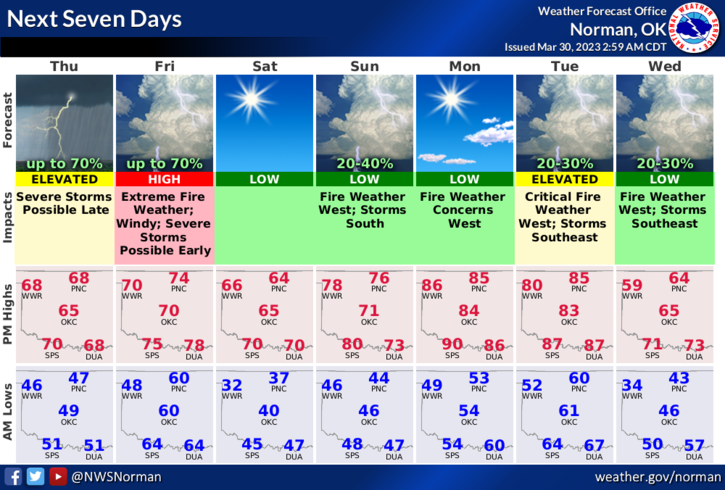
*Today will be windy and warm per the forecast below. The Fire Danger is in the Elevated zone. Friday we will be in a RED FLAG WARNING with an extremely high chance for fires. Chance for rain here since the storm system out west, the dryline setup and a cold front aren’t quite synced for the normal severe weather scenario, are low. If any storms were to form, they would most likely be elevated with a hail threat. We’ll just have to wait and see how this mess comes together if at all.
*Per the FIRE DANGER; NO controlled burning at all today and tomorrow is requested. We are not in a burn ban but please use good common sense. On Friday, humidity is forecast to be in the 8 to 10% area which is extremely low. If you see any smoke or fire, call 911 immediately.
*Overall, we’ll be ok so enjoy the day and be careful. Here is your forecast from the NWS/NORMAN:
Today- Mostly sunny this morning, then cloudy with a slight chance of showers and thunderstorms this afternoon. Patchy blowing dust this afternoon. Breezy with highs in the upper 60s. South winds 15 to 25 mph with gusts up to 40 mph. Chance of rain 20 percent.
Tonight- Mostly cloudy. Patchy blowing dust in the evening. A slight chance of showers and thunderstorms this evening and after midnight. Breezy. Near steady temperature in the lower 60s. South winds 20 to 25 mph with gusts up to 40 mph. Chance of rain 40 percent.
HAVE A GOOD DAY!