0425L-THURSDAY UPDATE FROM ENID/GARFIELD COUNTY EMERGENCY MANAGEMENT-5/24/18
1- A FLOOD WARNING IS IN EFFECT FOR NORTHERN WOODS AND NW ALFALFA COUNTIES. SOME OF THOSE AREAS HAVE RECEIVED 4 to 8 INCHES OF RAIN. IF YOU ARE TRAVELING IN THAT AREA, BE EXTREMELY CAREFUL AND PAY ATTENTION TO POSTED SIGNS.
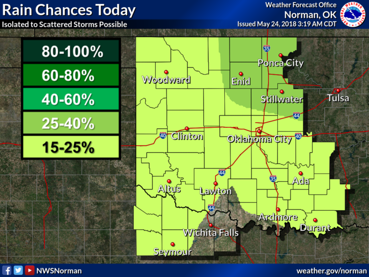
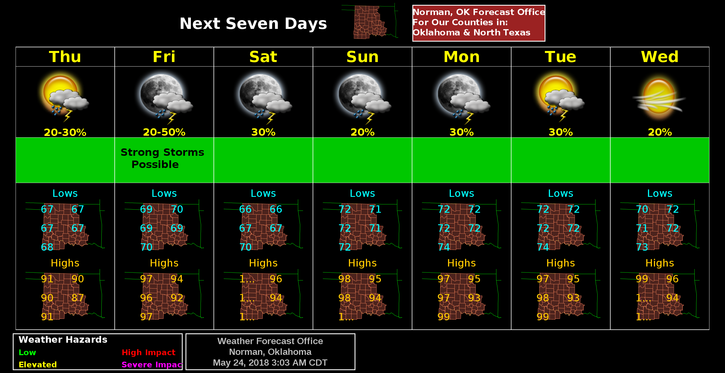
2-We are in a GENERAL RISK for thunderstorms today. Friday, that risk increases some to a MARGINAL RISK. The atmosphere, per guidance, is like a late June atmosphere. Not much in winds aloft but where storms build in an unstable area, they will produce a lot of rainfall in a short amount of time. Just stay aware of the weather and be careful in and around thunderstorm activity. The main threats wherever storms occur will be heavy rainfall, hail, and winds.
3- Be sure to download our GARFIELD COUNTY EM app. The biggest part of being prepared here in Garfield County is our app.
4- Overall, a little muggy and hot today. Here is your forecast from the NWS/NORMAN;
Thursday-Showers and thunderstorms likely, mainly before 7am. Partly sunny, with a high near 92. South wind 7 to 13 mph. Chance of precipitation is 60%. New rainfall amounts of less than a tenth of an inch, except higher amounts possible in thunderstorms.
Thursday Night-30 percent chance of showers and thunderstorms before 8pm. Partly cloudy, with a low around 70. South southeast wind 8 to 14 mph, with gusts as high as 20 mph.
HAVE A GOOD DAY AND WE’LL ADVISE AS NEEDED.
MIKE