0250L-THURSDAY OUTLOOK FROM GARFIELD COUNTY EMERGENCY MANAGEMENT-9/14/23
* Mid-70s temps are in store today with lite southeast winds. We will continue to warm up and we’ll most likely hit the 80s by Sunday. There is a 50% chance for rain during the day into the overnight hours but rainfall is expected to be less than .25 of an inch if it rains here. We’ll see what happens. Per the fire danger, we are still mostly dry. Soil is drying out from the rainfall on Monday but the foliage is very dry and it will burn. Continue to use caution if doing any controlled burning and as always, if you see smoke or fire, CALL 9-1-1.
* For you weather nuts out there, here is a link to our website links page that covers anything weather pertinent to our region and the oceans- https://gcem.org/links/
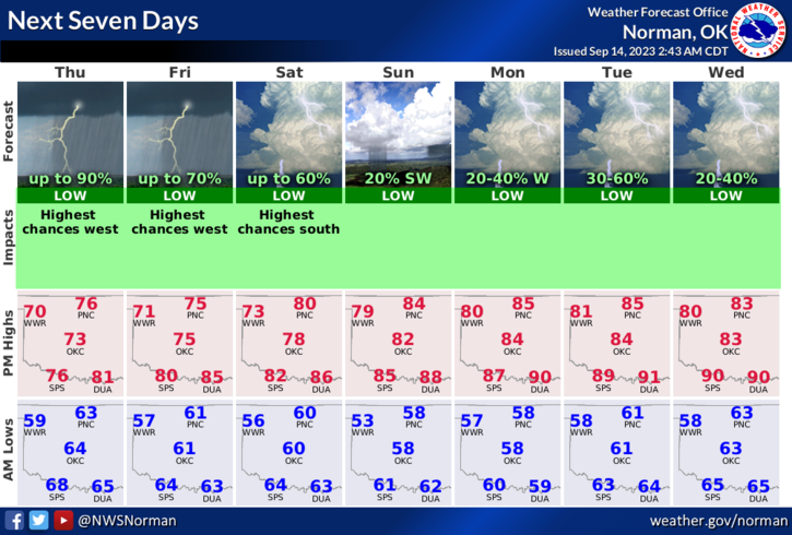
* Overall, we’ll be ok. Here is your forecast from the NWS/NORMAN;
Thursday- Mostly cloudy with a chance of showers with a slight chance of thunderstorms. Highs in the mid-70s. Southeast winds 5 to 10 mph. Chance of rain 50 percent.
Thursday Night- Mostly cloudy with a slight chance of thunderstorms. A slight chance of showers in the evening, then a chance of showers after midnight. Lows in the upper 50s. East winds 5 to 10 mph. Chance of rain 50 percent.
* Finally, as stated yesterday, Winter is just around the corner, so to speak, so look around the house, look around at work to see what needs to be done to keep the warm air in and the cold air out. It isn’t difficult to prepare but dollars can be saved by doing a little here and there to seal off those leaks. It’s only money!
HAVE A GOOD DAY!