0300L-THURSDAY OUTLOOK FROM GARFIELD COUNTY EMERGENCY MANAGEMENT-9/21/23
* The WSR-88D weather radar at Kegelman Field known as KVNX is still down. Replacement parts are ordered. A return to service is still undetermined at this time. Until then, we’ll utilize 3 other radars that give us a higher view of our area.
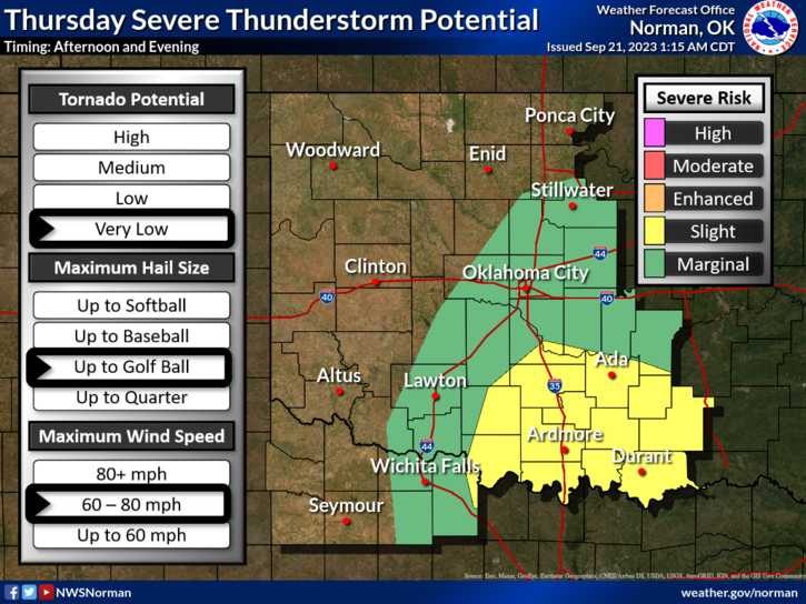
* For today- GENERAL RISK area for thunderstorms. There are several WHAT IF’S out there so just understand that depending on which “what if” occurs will be whether or not we see thunderstorms. You can read the SPC outlook and determine your particular what if here- https://www.spc.noaa.gov/products/outlook/day1otlk.html if you would like. Welcome to my world in making decisions.
*Overall, we should be ok so here is your forecast from the NWS/NORMAN;
Today- Mostly cloudy. A slight chance of showers and thunderstorms this afternoon. Highs in the mid-80s. Southeast winds 10 to 15 mph. Chance of rain 20 percent.
Tonight- Mostly cloudy. A chance of showers and thunderstorms in the evening, then showers and thunderstorms likely after midnight. Lows in the mid-60s. Southeast winds 5 to 10 mph. Chance of rain 70 percent.
Finally- foliage is still very dry out there so keep an eye out for smoke and fire. If you see any, call 9-1-1.
HAVE A GOOD DAY!