FROM GARFIELD COUNTY EMERGENCY MANAGEMENT-TUESDAY 8/29/17
In the wake of the storm system in southeast Texas, this situation just shows you that what you think may be impossible is actually possible. I’m talking about the issues that are on-going all around the southeast coast of Texas and Louisiana. With no steering winds aloft and this system stuck between 2 high pressure systems we all need to consider WHAT COULD HAPPEN HERE. It’s hard to watch all the misery that those folks are going through and it’s not just the flooding. Think about the aftermath. With virtually everything ruined, how is all that mess going to be cleaned up? How will the insurance companies actually handle this situation? How are folks going to get the refurbishing and or reconstruction of their homes and businesses done in a timely fashion before mold and mildew set in? Are those companies that do that type of work going to even be in business?
All of the above should be on your minds as we continue to go through that preparedness process here in the event we suffer some sort of catastrophic event. This is why I am a WHAT IF person. Some folks laugh at me about this but WHAT IF? In 1973 we had a storm system basically stop over the county and it dropped over 15 inches of rain over about 4-6 hours give or take. The result ended in death, trauma, and major property damage right here at home. Some of those issues have been mitigated.
This said, what you see on television should help you make a few decisions about how well you are prepared. What is your plan? Where will you go? How will you get there? How will you communicate with other loved ones? WHAT IF??????
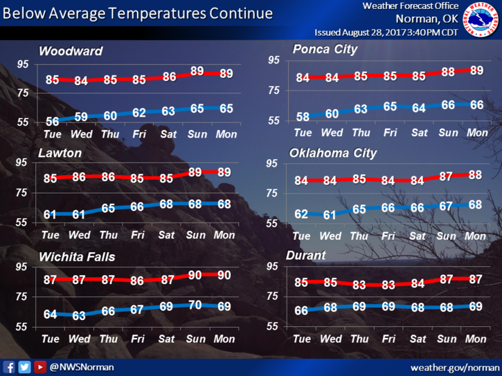
Here is your forecast from the NWS/NORMAN;
Tuesday-Sunny, with a high near 85. North northeast wind 5 to 10 mph.
Tuesday Night-Mostly clear, with a low around 61. Northeast wind 5 to 9 mph.
The rest of the week looks pretty good and should be similar to today give or take the temperatures.
STAY SAFE AND HAVE A GREAT DAY!!
MIKE