0350L-TUESDAY OUTLOOK FROM GARFIELD COUNTY EMERGENCY MANAGEMENT-12/20/22
Download our GARFIELD COUNTY EM app. You’re best prepared with it than without it.
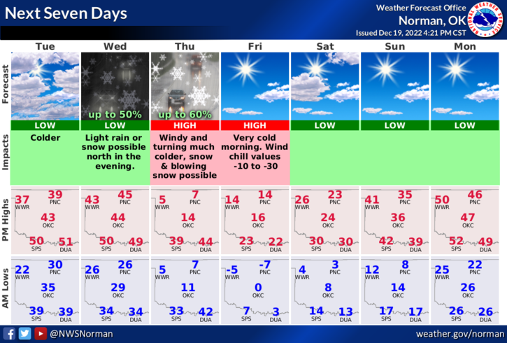
1- The first front, with colder air, that we have been talking about has moved through our area. No precipitation is expected but temps today will be a little lower than yesterday’s 55 degree temps that we enjoyed. Today’s high should be around 35 or so with colder wind chills. Wednesday’s temps may moderate some by our highs being in the low 40s until later in the overnight hours when the bottom falls out and then temps plummet.
2- The Thursday front appears to be speeding up a bit per guidance, so timing may be sooner than later early Thursday morning. 6There is also a low chance for some snow but if we do receive any, it would most likely be an inch or less. Any type of snow with the strong winds will make driving and visibility possibly a nightmare so use extreme caution.
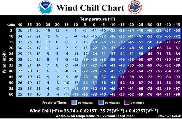
3- Again, the key element that is most concerning is the DANGEROUS WIND CHILL TEMPS. As stated yesterday, STAY INSIDE if you don’t have to be out. COVER YOUR SKIN if you plan on being outside while wind chill temps are very low. If you plan on traveling, take the proper precautions, and have blankets, food, a CHARGED cell phone, hand warmers, and water in case you have any type of car trouble or you end up in an accident. Try to keep track of where you are, while traveling so you can advise dispatch where you are in the event you end up in an accident or have any car issues. It helps responders get to you quicker. Hopefully, you don’t have any problems while driving.
Overall, we’ll be ok as long as YOU PREPARE accordingly for what you do every day. Here is your forecast from the NWS/NORMAN;
Today-Partly sunny. Cooler with highs in the mid-30s. North winds 5 to 10 mph.
Tonight-Partly cloudy in the evening, then becoming mostly cloudy. Cold with lows in the mid-20s. Northeast winds around 5 mph, becoming southeast after midnight.
HAVE A GOOD DAY!