0345L-TUESDAY OUTLOOK & INFO FROM GARFIELD COUNTY EMERGENCY MANAGEMENT-2/16/21
At 0300, it’s -10 degrees with light winds. If anyone has be outside today, use EXTREME caution and cover up. Be sure to download our GARFIELD COUNTY EM app and stay up with the latest weather info and news from the Energy issues along the central U.S.
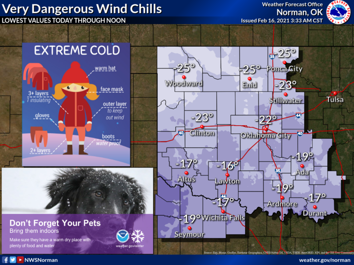
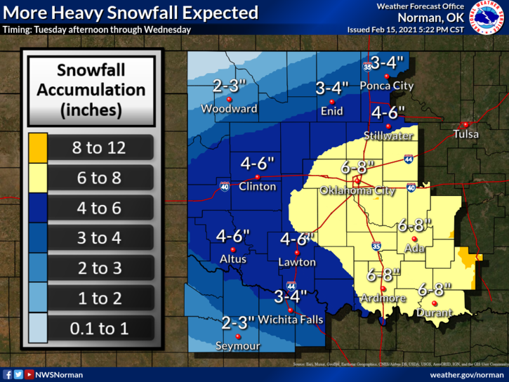
1- WINTER STORM WARNING in effect from noon today until 6pm Wednesday. 4 to 6 inches of additional snow is forecast for the area. Winds will increase today thus lowering the wind chill temps. We could see them down around 25 to 30 below zero again today and through the next few days.
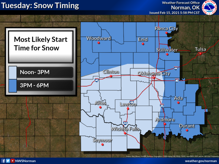
2- The graphs attached are an educated guess where the track of the storm system will go. Keep in mind this could fluctuate so we could see more or less snow. I will state here that clear skies and warmer temps would be a good thing right now. Overall, the winter storm is coming and we just need to hunker down for a few more days as best we can.
3-Additional Information concerning the energy issue with SSP and how this could affect us has been requested. That stated, OGE officials have sent out information on how to conserve energy so I will attach it here;
- Here is some additional information that OGE has sent to us. REMEMBER, DON’T PANIC OVER THIS AND CONTINUE TO CONSERVE WHERE YOU CAN. I will be obtaining more info on this today. Listen to your local news stations for more info today.
OG&E will continue to communicate through multiple platforms with customers as SPP updates its status. In the meantime, OG&E continues to urge its customers to reduce electricity use.
Customers can help minimize further interruptions by taking simple conservation steps such as:
Postpone using major electric appliances such as stoves, dishwashers, and clothes dryers until mid-day or after 9 p.m. when the demand for electricity decreases
Turn off lights and appliances that you do not need or are not using
Businesses should minimize the use of lighting and electricity-consuming equipment as much as possible
Large consumers of electricity should consider shutting down or reducing non-essential production processes.
OVERALL, ON THIS AS STATED, CONSERVE WHERE POSSIBLE AND WE’LL GET THROUGH THIS. I HAVE A LOT OF QUESTIONS TOO SO WE’LL GET THE ANSWERS AND PASS THEM ALONG.
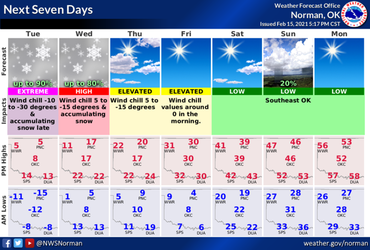
HERE IS YOUR FORECAST FROM THE NWS/NORMAN;
Tuesday-50% chance of snow this afternoon. Highs around 6. Southeast winds 10 to 15 mph.
Tuesday Night-Mostly cloudy. Snow likely in the evening, then a chance of snow after midnight. Lows around 4. East winds around 10 mph in the evening becoming light and variable. Chance of snow 70 percent.
I’ll advise with more information as I can obtain it.
STAY IN, STAY WARM, STAY SAFE
MIKE