FROM GARFIELD COUNTY EMERGENCY MANAGEMENT
Good morning!! Don’t you just hate it when I am smiling at 0330 in the morning? Thank goodness for COFFEE!!
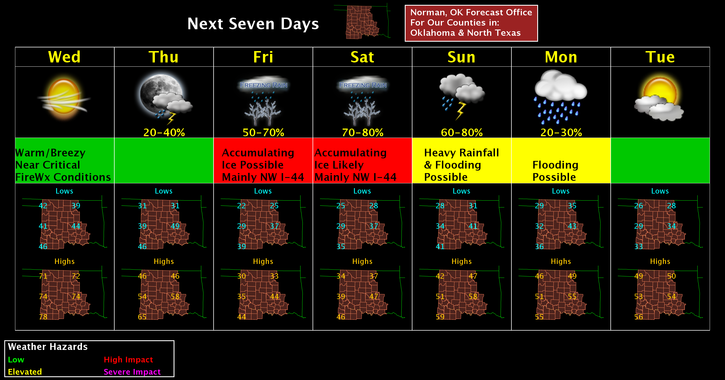
The winter event is still mostly on track to affect us starting late Thursday night. That said, just continue to prepare and hopefully everyone has changed travel plans for this weekend. I don’t care how good a driver you may think you are, but ICE will most likely prove you wrong. I don’t want to see anyone hurt or killed when they could have stayed home.
This first link is the NWS/NORMAN FORECAST DISCUSSION. If you have time, read it and you’ll have a good understanding of what their thinking is RIGHT NOW.
http://forecast.weather.gov/product.php?site=OUN&product=AFD&issuedby=OUN
This next link is very informative about WINTER WEATHER TYPES. It has pictures and explanations. I like this one as it explains the basics.
http://www.weather.gov/source/zhu/ZHU_Training_Page/winter_stuff/winter_wx/winter_wx.html
Here is your forecast from the NWS/NORMAN;
Today-Mostly sunny, with a high near 72. Southwest wind 10 to 18 mph, with gusts as high as 25 mph.
Tonight-Partly cloudy, with a low around 29. South southwest wind 9 to 11 mph becoming north after midnight.
Finally, the FIRE DANGER will be High today and you all know what that means. Be extremely careful using anything related to fire and I would advise NO CONTROLLED BURNING TODAY.
Have a super day and we’ll advise as needed.
Mike