0340L-TUESDAY OUTLOOK FROM GARFIELD COUNTY EMERGENCY MANAGEMENT-1/12/21
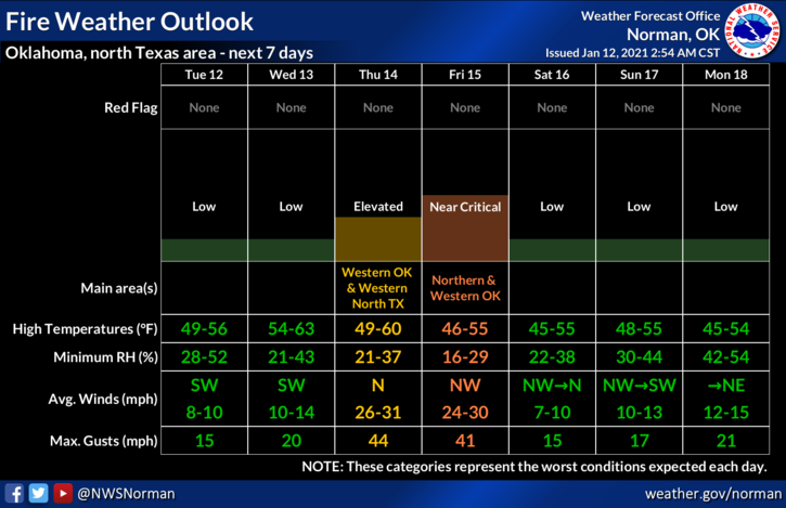
1- Nice weather will continue as a surface ridge moves slowly across Texas. Lots of sunshine and winds under 10 mph are expected along with warmer temperatures. Wednesday should be about the same as today and then a cold front pushes into the area Thursday. Cooler temps will follow the front and then a reinforcing shot of cold air comes in on Saturday. The main issues with the Thursday front will be the winds. The FIRE DANGER will increase since we’ll have drier air and low dew point temps and humidity. Wind “gusts” are forecast to possibly be in the 30-40 mph range. We’ll see what happens. As for any moisture with the fronts, it appears to be lacking so we should remain dry.
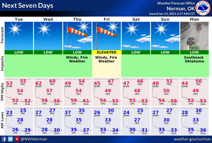
2- Overall, we’ll be ok so stay up with the latest and we’ll advise as needed. Here is your forecast from the NWS/NORMAN;
Tuesday- Sunny, with a high near 54. Southwest wind around 10 mph.
Tuesday Night- Clear, with a low around 28. Southwest wind around 10 mph.
3- REMINDER- all guidance that my information is based on comes from the NWS/NORMAN and the NWS/WICHITA. We are located in between both and are about the same distance away.
Be sure and download our GARFIELD COUNTY EM app. PREPAREDNESS=RESILIENCE.
HAVE A GOOD DAY!
MIKE