FROM GARFIELD COUNTY EMERGENCY MANAGEMENT-TUESDAY JUNE 27, 2017
Thunderstorms, some severe, have been terrorizing the area since 12:30 am. These storms have come out of Kansas and we can expect this trend off and on this week mainly from Thursday night into the weekend. These will most likely occur during the overnight hours so just keep in mind that this possibility exists as it has this morning. The main threats will be hail and wind. This may change so we’ll keep up with trends and advise as needed. Overall, we will survive. 🙂
Now, a PREPAREDNESS note; with the 4th of July coming up and folks buying fireworks, I want to stress a few things. It is ILLEGAL for fire off those fireworks on county roads and within the city limits of Enid. Fines are high if you are caught. If you start a fire out in the county and you are caught, you “may” have to pay for the response. That will get expensive real quick. GET PERMISSION out there from landowners if you plan on doing the fireworks thing on private property so you don’t get into trouble. We will check with landowners to make sure permission was given. THIS IS FOR YOUR SAFETY AND OURS. We don’t want any range fires.
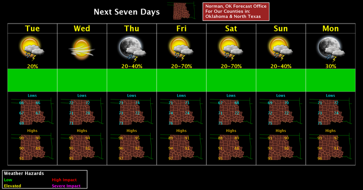
Enough said there. Here is your forecast from the NWS/NORMAN;
Tuesday-30 percent chance of showers and thunderstorms before 7am. Mostly sunny, with a high near 91. South southeast wind 5 to 14 mph, with gusts as high as 20 mph.
Tuesday Night-Mostly clear, with a low around 72. South wind 13 to 16 mph, with gusts as high as 23 mph.
HAVE A SUPER DAY!!
MIKE