0345L-TUESDAY OUTLOOK FROM GARFIELD COUNTY EMERGENCY MGMT-6/30/2020
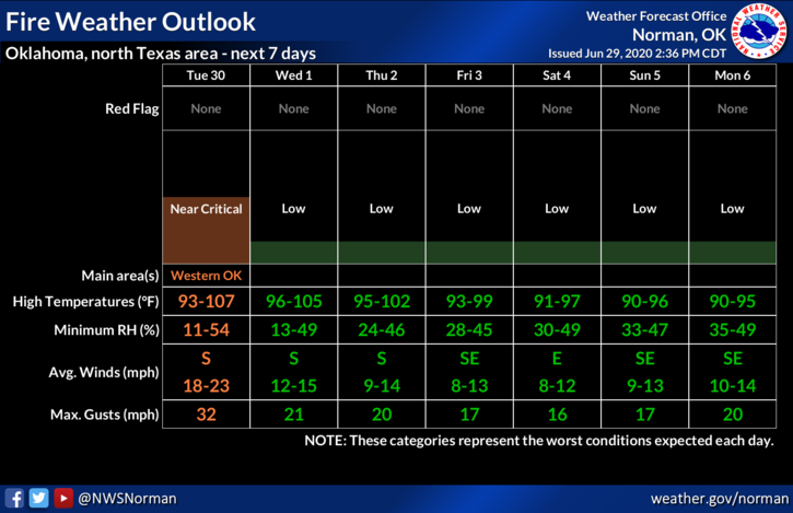
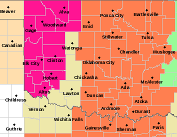
1- HEAT ADVISORY in effect from noon until 9pm this evening. GARFIELD COUNTY is included in this one. There is a RED FLAG WARNING in effect just to our west for roughly the western 1/3rd of the state. Basically it’s going to be extremely hot, humid, windy, and the fire danger near critical. See attached graph.
2- If anyone see’s smoke or fire, call 911 immediately so a response can get moving. Even if we saw some rainfall, our fire danger would still exist so help us prevent wildland fires by reporting suspicious activity too.
3- Weather-wise- hot and humid, thus the heat index today. Even though the graph attached shows us in a 103 heat index area, we could see those up to 106. Humidity may fall into the mid-20s by 4pm or so today along with winds sustained at 20mph with higher gusts. Just remember that firefighters are NOT IMMUNE to the heat, it affects us too. 2 tips for today:
a- NO CONTROLLED BURNING, b- NO FIREWORKS
4- Here is your forecast from the NWS/NORMAN;
Tuesday-Sunny and hot with a high near 103. Heat index values as high as 106. South wind 15 to 25 mph with gusts as high as 30 mph.
Tuesday Night- Low around 73 with South wind 10 to 20 mph, with gusts as high as 28 mph.
HAVE A GOOD DAY AND STAY COOL
MIKE