FROM GARFIELD COUNTY EMERGENCY MANAGEMENT-WEDNESDAY-12/20/17
REMINDER FOR THOSE ON FACEBOOK; I don’t monitor Facebook all day long. I also don’t have messenger on my phone as it doesn’t work very well. If you need information from me, email me at mike@gcem.org and I can answer your questions in a timely fashion. You can text me if needed.
Enjoy today and part of Thursday. Then the front pushes through and temps will steadily fall. It appears we will be borderline on any precipitation shortly after the frontal passage. One thing is for sure, IT’S GOING TO GET COLDER!!
Here is this morning’s Area Forecast Discussion if you want to take a few minutes and read. This will change some as data changes in future discussions;
https://forecast.weather.gov/product.php?site=NWS&issuedby=OUN&product=AFD
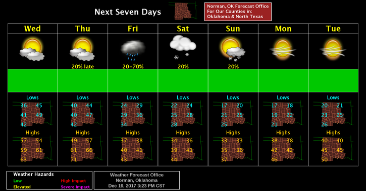
Here is your forecast from the NWS/NORMAN;
Wednesday-Cloudy, with a high near 54. North wind 5 to 7 mph becoming south in the afternoon.
Wednesday Night-Partly cloudy, with a low around 43. South southeast wind 7 to 14 mph, with gusts as high as 20 mph.
DOWNLOAD OUR EMERGENCY APP-GARFIELD COUNTY EM- YOU MAY NEED IT THIS WEEKEND!
Have a SUPER DAY!!
MIKE