0350L-WEDNESDAY OUTLOOK FROM GARFIELD COUNTY EMERGENCY MANAGEMENT-6/9/21
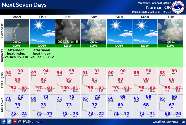
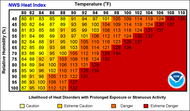
1- Our GENERAL thunderstorm risk today is extremely low. Our biggest threat will be the heat index. We will see high temps in the low 90s but the heat index looks like it will reach 100 later this afternoon. Thursday’s heat index will be around 105 with high temps in the mid-90s. Stay hydrated and take a few more short breaks if needed. Don’t over do it and keep the shade in site!
2- I will keep the link here for the heat issues we discussed yesterday. Here it is: https://www.weather.gov/safety/heat This information comes from the NWS/NORMAN.
3- Overall, we ‘ll be ok but keep in mind that it will be extremely humid and the heat index will play a major roll through the weekend. We’ll cool off some early next week but it may not be noticeable.
4- Here is your forecast from the NWS/NORMAN;
Today-Partly cloudy. Highs in the lower 90s. Southeast winds 10 to 15 mph.
Tonight-Mostly clear. Lows in the lower 70s. Southeast winds around 10 mph in the evening becoming light and variable.
FINALLY- be sure and download our GARFIELD COUNTY EM app. Its loaded with great info and advisories and warnings from the NWS push through our app as info is issued.
HAVE A GOOD DAY!!
MIKE