0325L-WEDNESDAY OUTLOOK FROM GARFIELD COUNTY EMERGENCY MANAGEMENT-2/16/22
I have a weather briefing at 11 am this morning. I will put out an update either written or do a live broadcast on the E.M page on facebook BEFORE 1330L. The shortcut to the EM page on facebook is @EGCEM
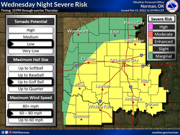
1- WINTER STORM WATCH in effect for us from tonight thru Thursday afternoon. MARGINAL RISK for severe weather later this evening. SLIGHT RISK to our south. There is a TORNADO risk in the southern part of the state. If you plan on traveling south, keep this in mind for later this evening.
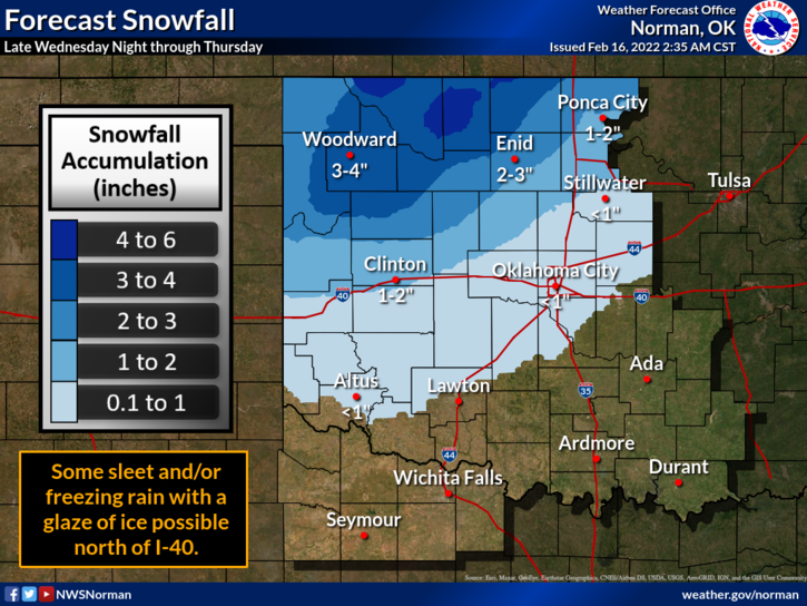
2- IF it rains here, we are looking at a 7-9 pm start time. THIS WILL VARY. As a cold front enters the area later this evening, we may see a transition over to some freezing rain and then snow from around 0300 into the day on Thursday. Latest data shows we might see 2 to 6 inches along with a glaze of ice. Winds may exceed 45 mph possibly giving us blizzard conditions for a short time tomorrow. This could change. There is a lot of uncertainty with some of this as timing will be a large factor.
3- There is NO need to panic and we will see a Multi-Hazard storm system push through but it’s not the first one we’ve seen. The risks are there BUT not out of control. Instability could be worse and the main weather events will occur after dark. If this storm system was moving in during late April or May, everything would be a different story.
4- OVERALL, we’ll be ok. Make sure you get our GARFIELD COUNTY EM app and you’ll be able to keep up with what’s happening from us and the NWS. Here is your forecast from the NWS/NORMAN;
Wednesday-Partly cloudy. Highs in the mid-70s. South winds 15 to 25 mph with higher gusts.
Wednesday Night-Thunderstorms likely in the evening, then rain showers, snow, freezing rain and a slight chance of thunderstorms after midnight. Much colder. Lows in the mid-20s. Southeast winds around 15 mph shifting to the north 15 to 25 mph, with higher gusts after midnight.
Have a good day!