0400L-SATURDAY UPDATE FROM ENID/GARFIELD COUNTY EMERGENCY MANAGEMENT-9/29/18
FIRST WORD– OCTOBER 30, 2018, be sure to register for our seminar. See details on the front page of our gcem.org website and download our GARFIELD COUNTY EM app.
1- A shower snuck in during the night and we could see another one this morning. Nothing major is expected. The cool front has stalled and will retreat back to the north today. We should see sunshine this afternoon.
2- As I see it, it will be a forecasters nightmare this week as what models say and what actually happens could be 2 different things so as stated in previous posts, keep a light jacket and an umbrella in the car or the truck and you should at least be prepared for changes as they occur.
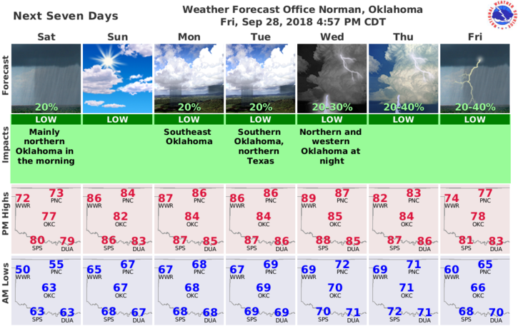
3-For the next week or so, high temps will “average” in the 80’s and lows in the mid to upper 60’s. This will vary for those that want exact numbers. By the way, that word “exact” doesn’t exist in my world.
4-Here is your forecast from the NWS/NORMAN;
Saturday-Cloudy. A slight chance of rain showers and patchy drizzle in the morning. Patchy fog in the morning. Highs in the lower 70s. South winds around 10 mph. Chance of showers 20 percent.
Saturday Night-Partly cloudy. Warmer. Lows in the upper 60s. South winds 10 to 15 mph.
HAVE A GREAT DAY AND REMEMBER-PREPAREDNESS STARTS WITH “YOU”
MIKE