0345L-FRIDAY OUTLOOK FROM GARFIELD COUNTY EMERGENCY MANAGEMENT-2/19/21
1- GARFIELD COUNTY EM is our emergency notification app. Preparedness is key to being ready for anything that may affect you. This app is loaded with info you can read, you can put essential info into it for you and always know that NWS & GCEM INFORMATION COMES THROUGH AUTOMATICALLY. YOU are your first line of defense; OUR app is your weapon of knowledge. Download it today!
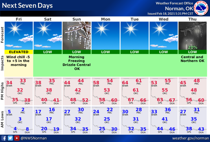
2- We are slowly going to be warming up. Until the snowpack is gone and some of that cold wetness on the ground evaporates, it will seem cooler than the actual air temp but we will get there. Forecast high for today around 32. It’s going to be nice outside compared to the last few weeks except the wind may spoil it a little. At least we are warming up.
3- There is a chance we may see some freezing fog Saturday morning so if you get out early, be careful. Here is your forecast from the NWS/NORMAN;
Friday-Mostly sunny with a high near 31. Wind chill values as low as -7. South wind 5 to 15 mph, with gusts as high as 20 mph.
Friday Night-Patchy freezing fog after midnight. Partly cloudy, with a low around 14. South wind 5 to 10 mph.
FINALLY; I have received several calls concerning broken pipes and other water issues. None of these folks knew where their water shutoff was. On the preparedness level, look for that shutoff so if in a week or so a pipe says, “time to break”, you will know where the shut off valve is. I know that desperation because when I was going to college in prehistoric times, I found myself in the same situation. It’s all part of the learning process and life.
HAVE A GOOD DAY AND STAY WARM.
MIKE