0330L-THURSDAY OUTLOOK FROM GARFIELD COUNTY EMERGENCY MANAGEMENT-2/18/21
1-GARFIELD COUNTY EM is our emergency notification app. It’s the best way for us to push info to you and NWS information comes through automatically. Want to be prepared and stay prepared? There is lots of information within the app too. Download it today!
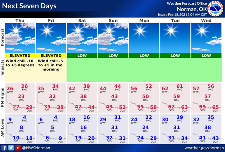
2- Over the next several days the cold temps will be overcome by warmer temps. This will be a slow process until the snowpack melts off. There is hope as we look to get back up into the 40s & 50s this up and coming week. Wind chill temps will still be low so continue to take the proper precautions. Also, the roads will begin to clear off but BE EXTREMELY CAREFUL early in the up and coming days as overnight lows will be below freezing and there is a possibility of ice on the roads.
3-Overall, things went as well as expected but this weekend I feel everyone should take a few minutes to re-evaluate your individual states of preparedness. Several folks were not prepared for this and severe storm season is coming. How can you be better prepared? Read the first paragraph above and follow this link to our preparedness guide. It may help you with that process. Here it is- https://gcem.org/wp-content/uploads/2019/05/FamilyPreparednessGuide2019.pdf
4- Here is your forecast from the NWS/NORMAN;
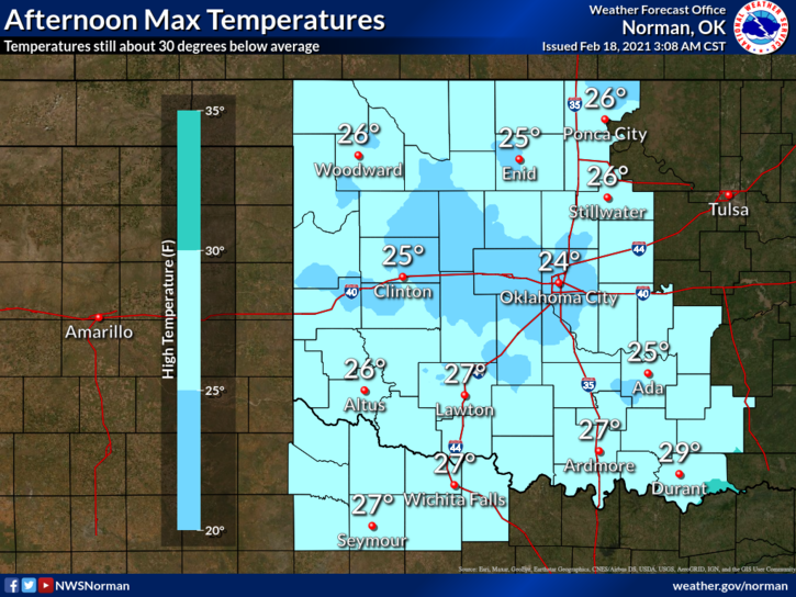
TODAY-Partly sunny, with a high near 22. Wind chill values as low as -9. North wind 5-10 mph.
TONIGHT-Partly cloudy with a low around 5. North northwest wind around 6 mph becoming southwest after midnight WITH WIND CHILL TEMPS AROUND -6.
HAVE A GOOD DAY AND STAY WARM
MIKE