0355L-FRIDAY OUTLOOK & INFO FROM GARFIELD COUNTY EMERGENCY MGMT-7/10/2020
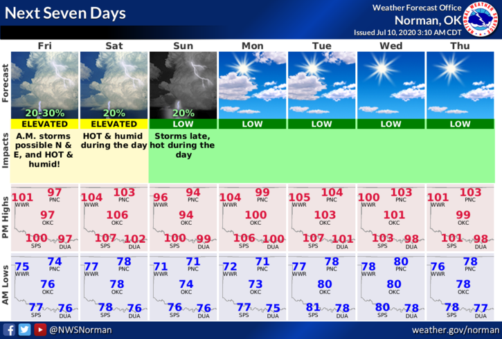
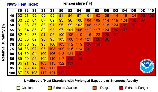
1- HEAT ADVISORY IN EFFECT FROM NOW UNTIL SATURDAY EVENING AT 7PM. Heat index values up to 110 are possible as hot temps and high humidity continues. Saturday will be our most DANGEROUS day this week as temps will be around 108. The FIRE DANGER is up there too, so be extremely careful out there.
2- We are in a GENERAL THUNDERSTORM RISK AREA today with our higher risk this morning as storms in Kansas could possibly move our way as they did yesterday. We will be in a MARGINAL RISK on Saturday. We’ll see what happens for sure. Here is your forecast from the NWS/NORMAN;
Today-Mostly cloudy with a 20% chance of thunderstorms in the morning, then partly cloudy in the afternoon. Highs around 100. Southeast winds 10 to 15 mph with higher gusts.
Tonight-Clear. Lows in the upper 70s. South winds 10 to 15 mph.
3- I am attaching heat related graphics so save them if you would like so you’ll have them. Also, be sure to download our GARFIELD COUNTY EM app.
HAVE A SUPER DAY!!
MIKE