0310L-FRIDAY OUTLOOK FROM GARFIELD COUNTY EMERGENCY MANAGEMENT-6/24/22
1-Here is your forecast from the NWS/NORMAN;
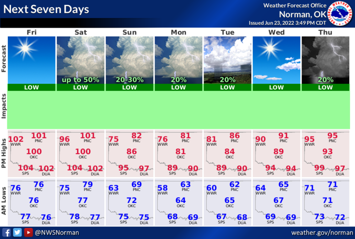
Today-Sunny, hot with highs around 103. South winds 15 to 20 mph with gusts up to 30 mph.
Tonight-Mostly clear. Lows in the upper 70s. South winds 15 to 20 mph with gusts up to 30 mph.
2- HOT, but a cool down is coming late Saturday evening and temps will drop into the 80s through mid-week. Overnight lows will be in the 60s. That should feel a little better at least for a little bit. Just remember that we are in summertime so just stay cool, drink plenty of fluids, and pace yourself while working outdoors.
3- We will have a chance for thunderstorms late Saturday into Sunday. The Main threat as it looks right now would be torrential rainfall and wind. We’ll see what happens.
FINALLY- We are still in a severe drought situation right now. That said, dryer air will be pumped in from the southwest and the FIRE DANGER will definitely increase. If you see smoke or fire, call 911 immediately.
FIREWORKS- It is illegal to fire them on county roads or near any crop or structures. If you start a fire out there and get caught, you may be responsible not only for the damage, but for the response too. That could be costly. The grass looks green but its very dry and WILL BURN. Please refrain from illegal activities out there. Thank you.
HAVE A GOOD DAY!!