0400L-SUNDAY OUTLOOK FROM GARFIELD COUNTY EMERGENCY MANAGEMENT-2/14/21
GARFIELD COUNTY EM is our emergency notification app. Download it now so you can keep up with NWS and GCEM information.
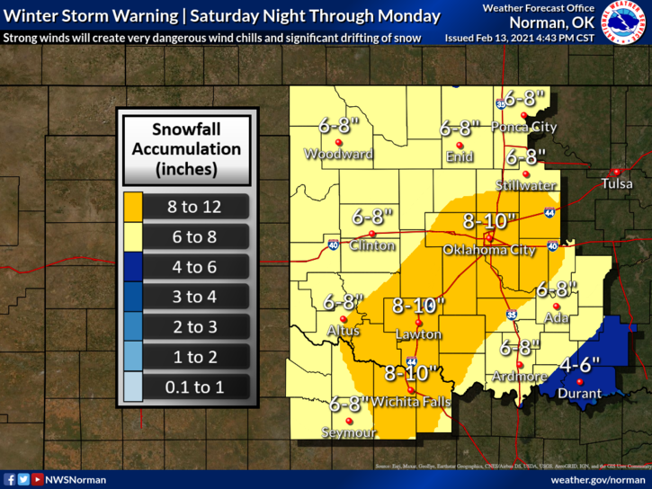
1-WINTER STORM WARNING IN EFFECT UNTIL 6PM ON MONDAY. 5-10 INCHES OF SNOW IS POSSIBLE. DANGEROUSLY LOW TEMPERATURES AND WIND CHILL TEMPS WILL BE THE PRIMARY THREAT THROUGH THIS WHOLE EVENT. BLIZZARD CONDITIONS MIGHT BECOME AN ISSUE AS SNOW ACCUMULATES AND BLOWS ACROSS ROADWAYS THUS DECREASING VISIBILITY. USE EXTREME CAUTION IF YOU JUST HAVE TO BE OUT. This is Round 1 of several between now and next Thursday. Hopefully, everyone has prepared for this.
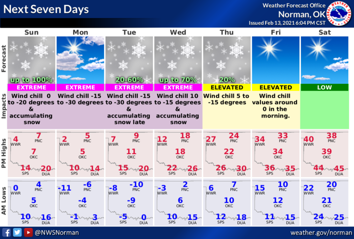
2- As I type this info this morning keep in mind that our high temp will be around 5 degrees and with the strong NNE winds, our wind chill will be dangerously low around -20 below zero. I cannot stress this enough that these wind chill temps are extremely dangerous. COVER YOUR SKIN if you have to be outside. Here is a link to the NWS/WINTER WEATHER PAGE SO EVERYONE CAN RE-READ IT. Here it is- https://www.weather.gov/safety/winter
3- The above said, here is your forecast from the NWS/NORMAN;
Sunday-Snow. The snow could be heavy at times. Widespread blowing snow. High near 5. Wind chill values as low as -20. North northeast wind 15 to 25 mph, with gusts as high as 30 mph. Chance of precipitation is 100%. New snow accumulation of 4 to 6 inches possible.
Sunday Night-50 percent chance of snow. Cloudy, with a low around -7. Wind chill values as low as -23. North wind 15 to 20 mph, with gusts as high as 30 mph.
FINALLY, if anyone takes any good pics that you want to share with us for spotter training purposes, feel free to send them to me at mike@gcem.org
STAY IN, STAY WARM, STAY SAFE. HAVE A GOOD DAY!
MIKE