0420L-SUNDAY UPDATE FROM ENID/GARFIELD COUNTY EMERGENCY MANAGEMENT-7/15/18
1-We are in a GENERAL RISK AREA for thunderstorms this afternoon and tonight. This may be the trend for the next several days. If storms occur, heavy rainfall and winds will be the main threats. Otherwise, it will be very muggy and hot outdoors.
2-There will be a boundary in southern Kansas that could be a focus point for storms Monday and Tuesday so we’ll see how this affects the area. For today, winds aloft are very weak so storms, if they occur, will be surfaced based and may occur just about anywhere.
3- Just keep in mind that storms are not expected to be severe BUT given the nature of the atmosphere and weak winds aloft, winds from collapsing storms and hail if storms can build high enough would be the bigger threats. Also, if we receive ample sunshine, this would cause greater instability so just stay weather aware and you’ll be ok.
3- Here is your forecast from the NWS/NORMAN;
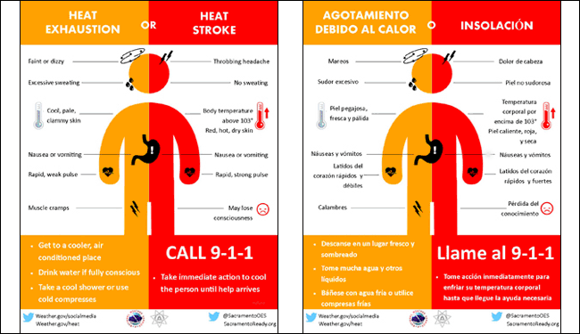
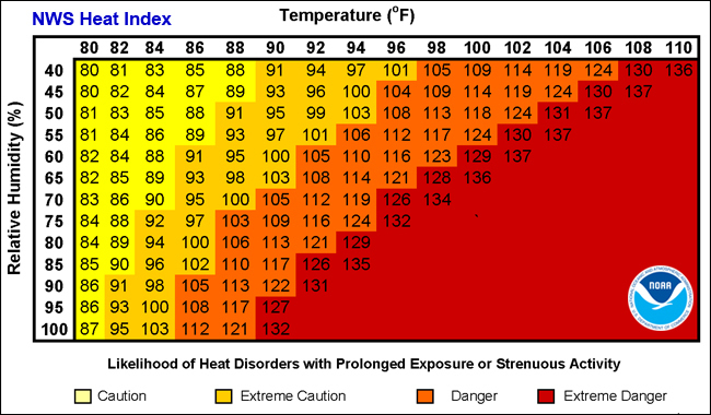
Sunday-30 percent chance of showers and thunderstorms, mainly after 1pm. Partly sunny and hot, with a high near 97. Heat index values as high as 101. South wind 5 to 10 mph.
Sunday Night-30 percent chance of showers and thunderstorms, mainly before 1am. Mostly cloudy, with a low around 76. South wind 5 to 10 mph becoming calm after midnight.
HAVE A GOOD DAY!!
MIKE