0330L-SUNDAY OUTLOOK FROM GARFIELD COUNTY EMERGENCY MANAGEMENT-10/23/22
WIND ADVISORY FROM 10 AM UNTIL 11 PM TONIGHT. BIGGEST THREAT WILL BE WINDS 20-30 MPH WITH WIND GUSTS UPWARDS TO 50 MPH.
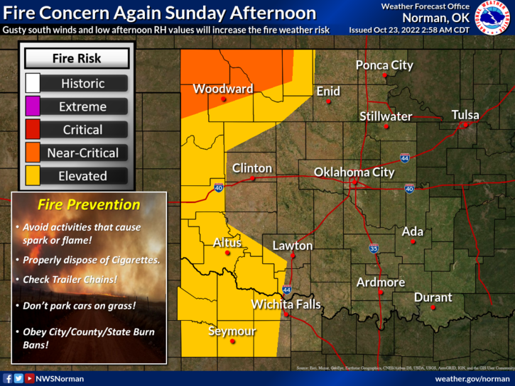
1- No watches here today at the time of this typing along the fire weather situation but it’s very dry and the danger is still critical. Humidity will be a little higher today but depending on where the dryline sets up will depend on where the deeper moisture is. Our best chance for rain will be late evening and overnight IF it occurs.
2- WHAT IF?
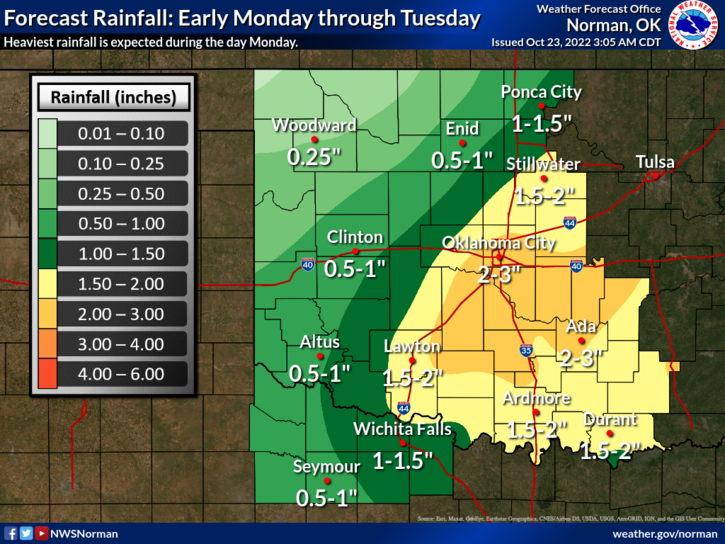
We have a cold front coming on Monday, we have a dryline setting up out west, we allegedly have moisture coming our way. Timing for showers and thunderstorms will be iffy. There are several scenarios that could occur all based on timing so we’ll have to wait and see where everything comes together but if rain occurs, it would most likely be during the overnight hours tonight. We’ll see what happens.
3- Overall, we’ll be ok so here is your forecast from the NWS/NORMAN;
Today-Partly sunny this morning, then becoming mostly cloudy. Windy with highs in the mid-80s. South winds 20 to 30 mph with gusts up to 45 mph.
Tonight-Mostly cloudy. A slight chance of showers before midnight, then a slight chance of thunderstorms after midnight. Windy with lows in the lower 60s. South winds 20 to 30 mph. Gusts up to 50 mph, decreasing to 40 mph after midnight. Chance of rain 50 percent.
HAVE A GOOD DAY!