0400L-THURSDAY UPDATE FROM ENID/GARFIELD COUNTY EMERGENCY MANAGEMENT-6/14/18
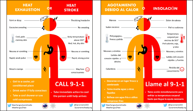
1- HEAT will be the issue through the weekend. If you have had Heat Exhaustion or even a Heat Stroke issue in the past, you need to be VERY CAREFUL while outdoors. It won’t take long for those effects to reinstate themselves in you. Once these issues have occurred, even a mild case of either, it can take years to overcome the symptoms. BE EXTREMELY CAREFUL OUTSIDE IN THE HEAT.
2- High pressure will mostly dominate the area until later in the weekend when an influx of moisture from the Gulf and Pacific move into the area. Heavy rainfall may become an issue IF we receive the rain. We’ll see how the forecast verifies.
3- FIRE DANGER-remember this? Harvest is ongoing right now so keep an eye out for smoke and fire and report either to 911. Sometimes machinery will start a fire and it isn’t noticed immediately. With winds over the next several days, fire can spread quickly.
4-I am attaching some new graphics. Share these if you want too.
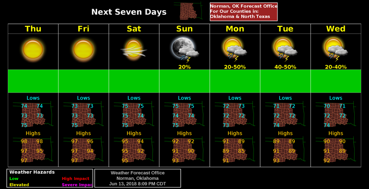
5- Here is your forecast from the NWS/NORMAN;
Thursday-Sunny and hot, with a high near 98. South wind 10 to 17 mph, with gusts as high as 24 mph.
Thursday Night-Mostly clear, with a low around 74. South wind 11 to 16 mph, with gusts as high as 23 mph.
HAVE A SUPER DAY AND STAY COOL
MIKE