0350L-THURSDAY OUTLOOK FROM GARFIELD COUNTY EMERGENCY MANAGEMENT-3/17/22
1- A Pacific front will push through the area today shifting winds and cooling us down a little. It might bring with it, a chance for thunderstorms. It doesn’t look real promising for our area but we’ll see what Mother Nature can throw at us. If we do see thunderstorms, the main threats would be hail and winds. We can only hope for the rain. Strong winds are expected behind this front out of the NNW so secure anything around the house that could take flight.
2- The Fire Danger is still in the critical area right now but with higher humidity, it lessens the threat a little. Fire Departments will remain on stand-by for fires here and also outside of the county. Please use EXTREME CAUTION utilizing anything related to fire. If you see smoke or fire, call 911. By the way, NO controlled burning is requested today.
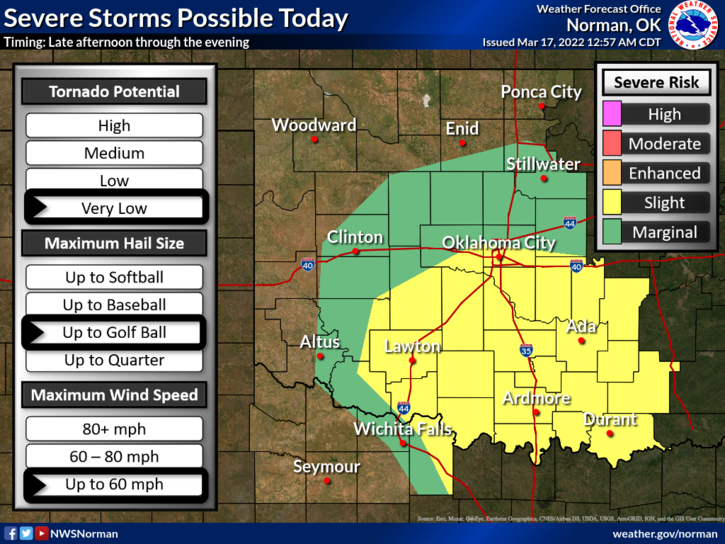
3- There is a severe threat for thunderstorms to our south and east. If you plan on traveling that way, check out the latest forecast from the NWS OFFICE nearest your destination. Here is your forecast from the NWS/NORMAN;
Today-Partly sunny this morning, then mostly cloudy with rain likely with a slight chance of thunderstorms this afternoon. Highs in the lower 70s. Southeast winds 10 to 15 mph with gusts up to 25 mph. Chance of rain 60 percent.
Tonight-A chance of thunderstorms. Rain, breezy with lows in the mid-30s. North winds 15 to 25 mph with gusts up to 35 mph. Chance of rain near 100 percent.
HAVE A GOOD DAY!