0330L-THURSDAY OUTLOOK FROM GARFIELD COUNTY EMERGENCY MANAGEMENT-10/22/2020
ADVISORY: The first part of next week will be extremely cold compared to what we have been dealing with so far this fall. Make sure you have disconnected hoses from your home and have at least checked fluids in your vehicles. Low temps Monday through Wednesday WILL BE below freezing and we have a good chance to see some sort of winter precipitation through this 2-3 day period.
1- GARFIELD COUNTY EM. This is our notification app. Here in Garfield County you are NOT PREPARED without it. As the forecast starts to verify concerning winter type weather, it would benefit you to download this app. You will receive NO PANIC OR DRAMA updates from us and the National Weather Service, Just factual.
2- This morning, we’ll start out warm and we should reach highs in the mid-80s Winds will be a factor as we could see gusts upwards of 35-40 mph. We are in a Moderate Drought right now so keep an eye out for smoke and fire. If you see any contact 911 so the appropriate response can be dispatched.
3- THUNDERSTORMS are possible tonight as another cold front moves into the area. We are in a GENERAL RISK AREA. Temps will drop and we’ll see highs in the 40s on Friday. As the forecast modifies and verifies, we’ll update as needed. Any watches, warnings or advisories will automatically come through our app from the NWS/NORMAN. We’ll send out information as needed from our office too.
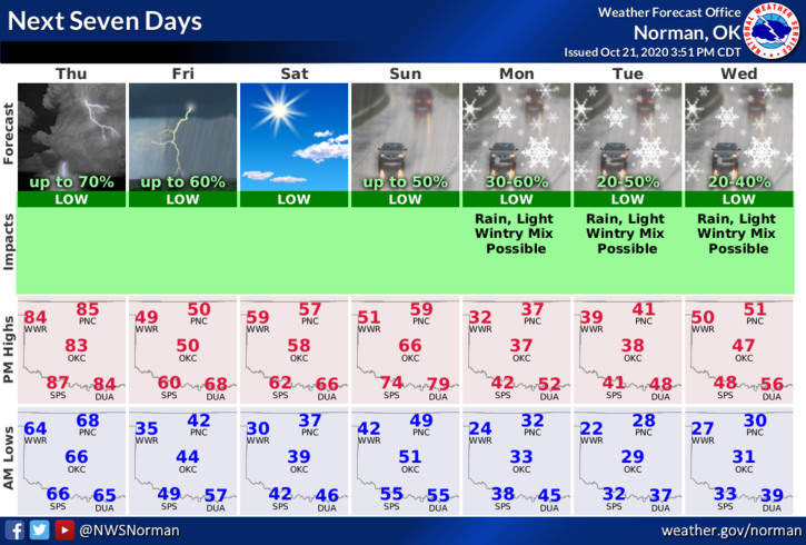
4- Here is your forecast from the NWS/NORMAN;
Thursday-Mostly sunny. Highs in the mid-80s. South winds 15 to 25 mph.
Thursday Night-Partly cloudy with rain showers likely and a slight chance of thunderstorms. Much colder. Lows in the upper 30s. South winds 10 to 20 mph shifting to the north after midnight. Chance of precipitation 70 percent.
HAVE A GOOD DAY!
MIKE