0350L-TUESDAY OUTLOOK & INFO FROM GARFIELD COUNTY EMERGENCY MGMT-2/4/2020
ATTENTION: Highs around the area will be near 32 degrees. If roads are wet, they may be slick. Take your time while driving and put your cell phones down. WIND CHILL TEMPS will be dangerously low later today and tonight so be careful while outdoors.
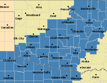
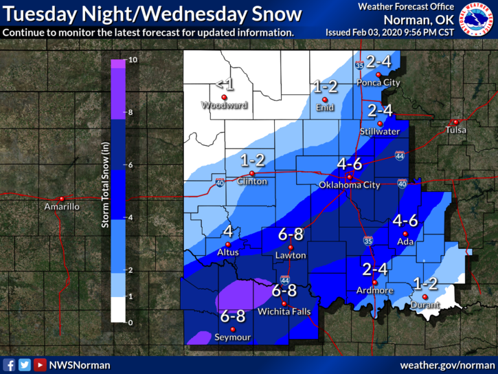
1- WINTER STORM “WATCH” in effect from Tuesday evening through Wednesday afternoon. See attached graph. We are not in this watch but we might see 1 to 2 inches of snow as this system moves through the area. This, of course, isn’t guaranteed but either way dangerous conditions will exist to our south and southwest.
2-KEY NOTE FOR EVERYONE WANTING TO TRAVEL; be prepared to stay overnight at or near your destination if snowfall becomes heavy enough to close roads. This could happen anywhere in the WATCH AREA so keep this in mind. No one knows exactly where the heavier showbands will actually occur, so use EXTREME CAUTION while driving later today, tonight, and Wednesday. ROAD CONDITIONS for us and all states around Oklahoma can be found on our front page at https://gcem.org website. Keep up with the latest information from the NWS/NORMAN. Be sure to download our emergency notification app-GARFIELD COUNTY EM.
3- Overall, we’ll be ok so if it does snow later this evening, just enjoy it and if you have to be out in it, just be careful.
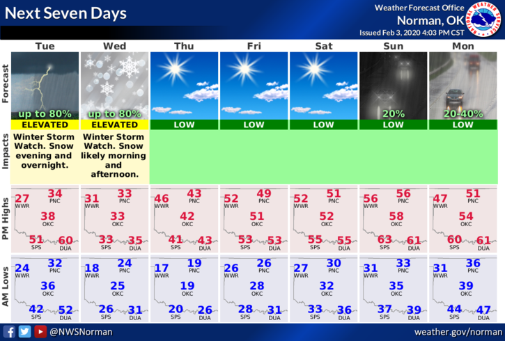
4- Here is your countywide forecast from the NWS/NORMAN;
Today-Cloudy with a slight chance of rain and light freezing rain in the morning, then a slight chance of rain late in the afternoon. Highs in the mid-30s. North winds 15 to 20 mph. Chance of precipitation 20 percent.
Tonight-Cloudy. A slight chance of snow in the evening, then a chance of snow after midnight. Lows in the lower 20s. North winds around 15 mph. Chance of snow 50 percent.
HAVE A GOOD DAY AND STAY WARM!
MIKE