0400L-WEDNESDAY OUTLOOK FORM ENID/GARFIELD COUNTY EMERGENCY MANAGEMENT-12/12/18
HIGH WIND WATCH IN EFFECT FOR THE WESTERN 1/3 OF OKLAHOMA FOR THURSDAY. GARFIELD COUNTY is not in the watch right now.
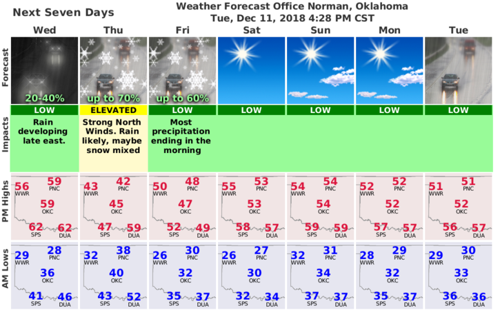
1- A storm system is coming that appears will bring us a “chance” for rain on Thursday and maybe a flurry or two Thursday night. The storm track will be south of us in Texas so our major issue will be the wind.
2- Sustained winds on Thursday will average 25-35 mph with gusts into the 40-45 mph range. This will change as this system gets closer. We’ll keep an eye out on this. Today looks really nice!
3- Again, wind is the issue, so secure anything around the house, business, farm, or whatever that could take unauthorized flight so your things don’t cause injury/damage to someone else. Also, the FIRE DANGER WILL BE ELEVATED FIRE due to wind so please call 911 if you see smoke or fire.
4- We’ll be ok overall, except ladies should expect a very bad hair day due to winds tomorrow and I would advise wearing pants. It won’t be a good day to wear a dress.
Here is your forecast from the NWS/NORMAN;
Wednesday-Sunny. Highs in the upper 50s. Light and variable winds becoming south around 10 mph in the afternoon.
Wednesday Night-Partly cloudy. A slight chance of rain after midnight. Lows in the mid 30s. Southeast winds around 10 mph shifting to the northeast 10 to 20 mph after midnight. Chance of rain 20 percent.
HAVE A SUPER DAY!!
MIKE