0310L-WEDNESDAY OUTLOOK FROM GARFIELD COUNTY EMERGENCY MANAGEMENT 01/17/24
*Warm temps are forecast for the area today and for a while on Thursday before another ARCTIC intrusion occurs. We could see temps in the upper 30s to low 40s. The only issue here will be the winds. They will average 15-20 mph with gusts upwards of 35mph. There goes that warm feeling.
*All the above said, you can find OKLAHOMA ROAD CONDITIONS HERE- https://ok.maps.arcgis.com/apps/Viewer/index.html?appid=023e821ebf7b4acd999ccfd58d92c3da
Many folks have been calling asking about this. Just FYI, Road conditions for all states around Oklahoma can be found on the gcem.org website. Just scroll down halfway on the front page and you’ll find them.
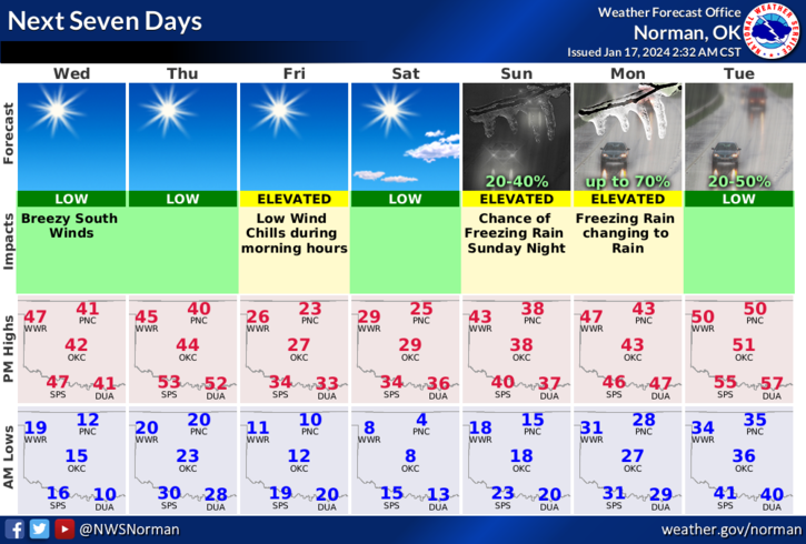
*As you’ll see in future forecasts, there may be an issue come Monday with some freezing rain in the state. Our area has a LOW chance for this but it’s not out of the question so pay attention to future forecasts & advisories. OVERALL, we’ll be ok just chilly so here is your forecast from the NWS/NORMAN;
Today- Sunny. Not as cool with highs around 40. South winds 15 to 20 mph with gusts up to 35 mph. Wind chill values as low as 4 below this morning.
Tonight- Partly cloudy in the evening, then clearing. Cold with lows around 20. Southeast winds 10 to 15 mph, becoming east 5 to 10 mph after midnight.
* NO ADVISORIES IN EFFECT AT THIS TIME. Be sure to download our GARFIELD COUNTY EM app and the CITYCONNECT app.
HAVE A GOOD DAY!