0345L-WEDNESDAY OUTLOOK FROM GARFIELD COUNTY EMERGENCY MANAGEMENT-10/14/2020
1- HOT, DRY, AND WINDY ALONG WITH A RISING FIRE DANGER. BE CAREFUL OUT THERE!! IF YOU SEE SMOKE OR FIRE, CALL 911!
2- We are expecting another cold front later tonight and it will cause the southerly winds to increase today with gusts upwards of 25 mph. After the front pushes through, we’ll see NNE winds with gusts upwards of 40 mph. No rain is expected but we’ll probably see a lot of dirt if you’re up at that time.
3- After today, cooler temps will be in store with highs in the 60s and lows in the low to mid 40s. Another front will affect the area during the weekend. It appears it will be dry for us at this time. We are in a Moderate drought so hopefully we can get that important first rain after getting the wheat planted.
4- Here is your forecast from the NWS/NORMAN;
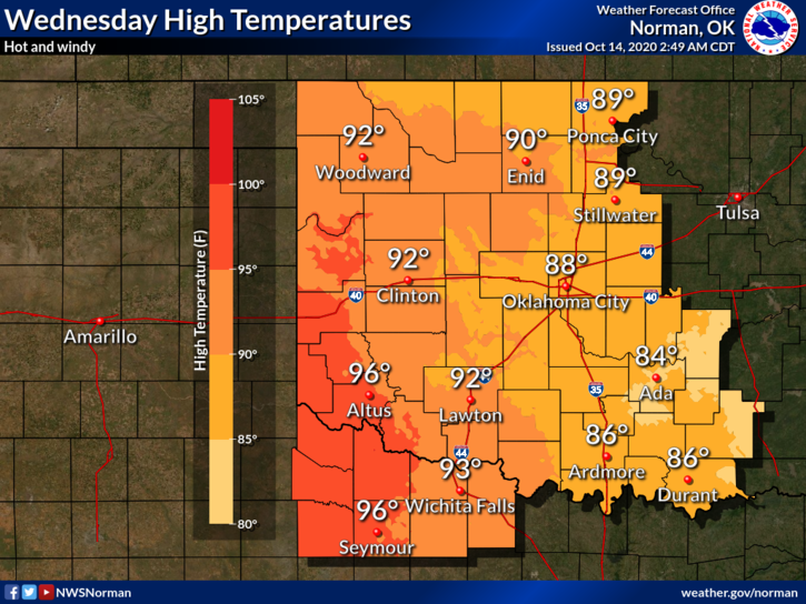
Wednesday- Sunny, with a high near 91. South southwest wind 15 to 20 mph, with gusts as high as 25 mph.
Wednesday Night- Mostly clear with a low around 53. Windy, with a south wind 10 to 15 mph becoming north northeast 20 to 30 mph in the evening. Winds could gust as high as 40 mph.
Be sure and download our GARFIELD COUNTY EM app. You’re not prepared without it!
HAVE A GOOD DAY!!
MIKE