0245L-THURSDAY OUTLOOK FROM GARFIELD COUNTY EMERGENCY MANAGEMENT-8/17/23
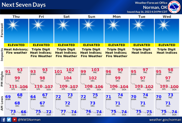
*GOOD MORNING!! It will be a bit warmer or hotter, whichever term you want to use, but it appears we’ll be just under the Heat Advisory criteria. It will be close. It wouldn’t surprise me to see us end up in an advisory later today but we’ll likely be there Friday into and thru the weekend. After the taste of early fall, we return to summertime temps and we’ll also deal with the wind. There were several controlled burns yesterday so remember to call them into dispatch and they’ll let us know what’s going on. That number is 580-234-(FIRE)-3473.
*If you see smoke or fire, call 9-1-1 immediately so the proper response can be sent. They will let you know if they are aware of it or not.
* Overall, we’ll be ok so here is your forecast from the NWS/NORMAN;
Today-Mostly sunny. Highs in the mid-90s. South winds 5 to 10 mph with gusts up to 20 mph, becoming northeast 10 to 15 mph with gusts up to 25 mph this afternoon.
Tonight-Mostly clear. Lows in the mid-60s. Northeast winds 10 to 15 mph.
*Download our GARFIELD COUNTY EM app and click on the GCEM Blog icon. You will find my daily posts there AND on the front page of our website at https://gcem.org
HAVE A GOOD DAY!